Madhya Pradesh: Difference between revisions
m Removed protection from "Madhya Pradesh" |
|||
| Line 25: | Line 25: | ||
== Geography == | == Geography == | ||
Madhya Pradesh spans an area of 308,252 sq km. It is bordered by Uttar Pradesh to the north, Chhattisgarh to the east, Maharashtra to the south, and Rajasthan to the west. The state is traversed by major geographical features like the | Madhya Pradesh spans an area of 308,252 sq km. It is bordered by Uttar Pradesh to the north, Chhattisgarh to the east, Maharashtra to the south, and Rajasthan to the west. The state is traversed by major geographical features like the Vindhya and Satpura ranges, and rivers such as the Narmada and Tapti. | ||
== History == | == History == | ||
Historically, the region has been ruled by ancient empires such as the Mauryas, Guptas, and the Paramaras. During the medieval period, it was influenced by Muslim rulers and later came under Maratha dominance. After India’s independence, Madhya Pradesh was formed on 1 November 1956 through the States Reorganisation Act. In 2000, its southeastern part was carved out to create the state of | Historically, the region has been ruled by ancient empires such as the Mauryas, Guptas, and the Paramaras. During the medieval period, it was influenced by Muslim rulers and later came under Maratha dominance. After India’s independence, Madhya Pradesh was formed on 1 November 1956 through the States Reorganisation Act. In 2000, its southeastern part was carved out to create the state of Chhattisgarh. | ||
== Demographics == | == Demographics == | ||
| Line 36: | Line 36: | ||
* Sex ratio: 931 females per 1000 males | * Sex ratio: 931 females per 1000 males | ||
* Population density: 236 persons/sq km | * Population density: 236 persons/sq km | ||
* Scheduled Tribes constitute about 21% of the population, including major communities like | * Scheduled Tribes constitute about 21% of the population, including major communities like Bhils and Gonds. | ||
== Economy == | == Economy == | ||
| Line 45: | Line 45: | ||
== Culture and Heritage == | == Culture and Heritage == | ||
The state is known for its rich cultural legacy. World Heritage Sites like the | The state is known for its rich cultural legacy. World Heritage Sites like the Khajuraho Temples, Sanchi Stupa, and the prehistoric Bhimbetka Rock Shelters are located here. It is home to diverse tribal cultures, folk traditions, classical music, and festivals. | ||
== See Also == | == See Also == | ||
* | * Bhopal | ||
* | * Indore | ||
* | * Khajuraho | ||
* | * Sanchi | ||
* | * Gond tribe | ||
== References == | == References == | ||
Revision as of 05:26, 26 August 2025

| |
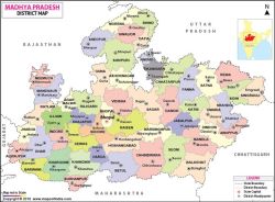
| Map showing the location of Madhya Pradesh | |
| Capital | Bhopal |
|---|---|
| Largest city | Indore |
| Official languages | Hindi |
| Area | 308,252 km² |
| Population | 72,626,809 (2011) |
| Established | 1 November 1956 |
| Time zone | IST (UTC+05:30) |
| Vehicle code | MP |
| Website | Official site |
Madhya Pradesh is a state located in central India. It is the second-largest state in the country by area and the fifth-largest by population. The state capital is Bhopal, while Indore is the largest and most populous city.
Geography
Madhya Pradesh spans an area of 308,252 sq km. It is bordered by Uttar Pradesh to the north, Chhattisgarh to the east, Maharashtra to the south, and Rajasthan to the west. The state is traversed by major geographical features like the Vindhya and Satpura ranges, and rivers such as the Narmada and Tapti.
History
Historically, the region has been ruled by ancient empires such as the Mauryas, Guptas, and the Paramaras. During the medieval period, it was influenced by Muslim rulers and later came under Maratha dominance. After India’s independence, Madhya Pradesh was formed on 1 November 1956 through the States Reorganisation Act. In 2000, its southeastern part was carved out to create the state of Chhattisgarh.
Demographics
As per the 2011 Census:
- Total population: 72.6 million
- Literacy rate: 69.32%
- Sex ratio: 931 females per 1000 males
- Population density: 236 persons/sq km
- Scheduled Tribes constitute about 21% of the population, including major communities like Bhils and Gonds.
Economy
The state's economy is primarily agrarian, with major crops including wheat, soybeans, pulses, and rice. Madhya Pradesh is rich in minerals such as coal, copper, and bauxite. It also has growing industrial and service sectors in cities like Indore, Bhopal, Gwalior, and Jabalpur.
Government
Madhya Pradesh functions as a parliamentary democracy with a unicameral legislature of 230 elected members. The Governor is the constitutional head, and the Chief Minister is the executive leader. The judiciary is headed by the Madhya Pradesh High Court based in Jabalpur.
Culture and Heritage
The state is known for its rich cultural legacy. World Heritage Sites like the Khajuraho Temples, Sanchi Stupa, and the prehistoric Bhimbetka Rock Shelters are located here. It is home to diverse tribal cultures, folk traditions, classical music, and festivals.
See Also
- Bhopal
- Indore
- Khajuraho
- Sanchi
- Gond tribe

